Latolato Trail: Difference between revisions
From Bulbapedia, the community-driven Pokémon encyclopedia.
Jump to navigationJump to search
Pokemaster97 (talk | contribs) No edit summary |
Pokemaster97 (talk | contribs) No edit summary |
||
| Line 30: | Line 30: | ||
{{oblivia}} | {{oblivia}} | ||
{{Stub|Location}} | {{Stub|Location}} | ||
{{ | {{DoubleProjectTag|Locations|Sidegames|every location in the Pokémon world and the Pokémon Sidegames, respectively.}} | ||
[[Category:Cities]] | [[Category:Cities]] | ||
[[de:Latolato-Pfad]] | [[de:Latolato-Pfad]] | ||
[[ja:ラトラトさんどう]] | [[ja:ラトラトさんどう]] | ||
Revision as of 14:50, 31 July 2011
| ||||

| ||||
| Connecting locations | ||||
|---|---|---|---|---|
| North | Mt. Latolato | |||
| South | Rand's House | |||
| West | None | |||
| East | Hinder Cape | |||
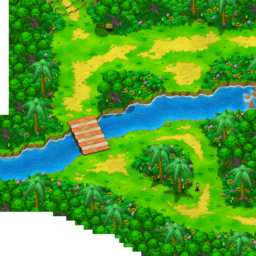
Latolato Trail (Japanese: ラトラトさんどう Ratorato Mountain Path) is a location in Pokémon Ranger: Guardian Signs.
It is located north of Rand's House, south of Mt. Latolato and west of Hinder Cape on Renbow Island. A field of Gracideas can be seen after crossing the river using Suicune.
Pokémon
| Pokémon | Poké Assist | Field | |
|---|---|---|---|
| Venusaur * | |||
| Ledyba | |||
| Flaaffy | |||
| Bellossom * | |||
| Skiploom * | |||
| Mudkip | |||
| Bibarel * | |||
| Mothim * | |||
| Cherrim * | |||
| Stunky * | |||
| Gible * | |||
| Shaymin * | None | ||
| Oblivia | ||||||
|---|---|---|---|---|---|---|
|
| ||||||
| ||||||
| This location-related article is a stub. You can help Bulbapedia by expanding it. |

|
This article is part of both Project Locations and Project Sidegames, Bulbapedia projects that, together, aim to write comprehensive articles on every location in the Pokémon world and the Pokémon Sidegames, respectively. | 
|