Latolato Trail: Difference between revisions
From Bulbapedia, the community-driven Pokémon encyclopedia.
Jump to navigationJump to search
Teddy6ursa (talk | contribs) |
Pokemaster97 (talk | contribs) No edit summary |
||
| Line 30: | Line 30: | ||
{{oblivia}} | {{oblivia}} | ||
{{Stub|Location}} | {{Stub|Location}} | ||
{{Project Locations notice}} | |||
{{Project Sidegames notice}} | |||
[[Category:Cities]] | [[Category:Cities]] | ||
[[de:Latolato-Pfad]] | [[de:Latolato-Pfad]] | ||
[[ja:ラトラトさんどう]] | [[ja:ラトラトさんどう]] | ||
Revision as of 19:38, 31 January 2011
| ||||

| ||||
| Connecting locations | ||||
|---|---|---|---|---|
| North | Mt. Latolato | |||
| South | Rand's House | |||
| West | None | |||
| East | Hinder Cape | |||
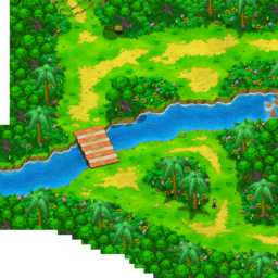
Latolato Trail (Japanese: ラトラトさんどう Ratorato Mountain Path) is a location in Pokémon Ranger: Guardian Signs.
It is located north of Rand's House, south of Mt. Latolato and west of Hinder Cape on Renbow Island. A field of Gracideas can be seen after crossing the river using Suicune.
Pokémon
| Pokémon | Poké Assist | Field | |
|---|---|---|---|
| Venusaur * | |||
| Ledyba | |||
| Flaaffy | |||
| Bellossom * | |||
| Skiploom * | |||
| Mudkip | |||
| Bibarel * | |||
| Mothim * | |||
| Cherrim * | |||
| Stunky * | |||
| Gible * | |||
| Shaymin * | None | ||
| Oblivia | ||||||
|---|---|---|---|---|---|---|
|
| ||||||
| ||||||
| This location-related article is a stub. You can help Bulbapedia by expanding it. |

|
This article is part of Project Locations, a Bulbapedia project that aims to write comprehensive articles on every location in the Pokémon world. |

|
This article is part of Project Sidegames, a Bulbapedia project that aims to write comprehensive articles on the Pokémon Sidegames. |