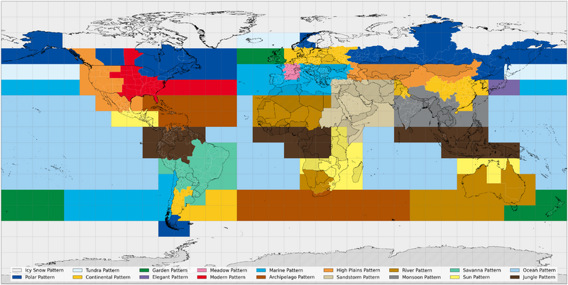
File:Vivillon locations 3DS.png
From Bulbapedia, the community-driven Pokémon encyclopedia.
Jump to navigationJump to search

Size of this preview: 800 × 402 pixels. Other resolutions: 2,560 × 1,287 pixels | 4,940 × 2,484 pixels.
Full-size image (4,940 × 2,484 pixels, file size: 1.53 MB, MIME type: image/png)
| This file is from the Bulbagarden Archives. The description from its description page there is shown below. |
File history
Click on a date/time to view the file as it appeared at that time.
| Date/Time | Thumbnail | Dimensions | User | Comment | |
|---|---|---|---|---|---|
| current | 06:13, 11 April 2023 |  | 4,940 × 2,484 (1.53 MB) | Abcboy | Resized |
| 05:28, 11 April 2023 | Error creating thumbnail: File with dimensions greater than 12.5 MP | 6,170 × 3,100 (2.06 MB) | Abcboy | An {{wp|equirectangular projection}} map of the possible countries/regions corresponding to each {{p|Vivillon}} form. The dots indicate the latitude/longitude coordinates associated with each country/region in the {{bp|Nintendo 3DS}} system software. Hatched countries/regions cannot be selected on a Nintendo 3DS system from any region. The source code used to generate this map is available in this GitHub repository: [https://github.com/abcboy101/vivillon abcboy101/vivillon] == Licensing ==... |
File usage
The following 2 pages use this file:

