Sophian Road: Difference between revisions
From Bulbapedia, the community-driven Pokémon encyclopedia.
Jump to navigationJump to search
No edit summary |
(Added layout) |
||
| (20 intermediate revisions by 9 users not shown) | |||
| Line 1: | Line 1: | ||
{{ | {{Route infobox | ||
|image=Sophian Road Ranger3.png | |||
|name=Sophian Road | |||
|jpname=ソピアナかいどう | |||
|jptranslit=Sopiana Highway | |||
|jptrans=Sopiana Highway | |||
|generation=4 | |||
|type=land | |||
|north=Mt. Sorbet | |||
|south=Aqua Resort | |||
|south2=Canal Ruins | |||
|west=Silver Falls | |||
|region=Oblivia | |||
|regionmap=Sophian Road Ranger3 map.png | |||
|mapsize=250px | |||
}} | }} | ||
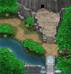
'''Sophian Road''' (Japanese: '''ソピアナかいどう''' ''Sopiana Highway'') is a location in {{g|Ranger: Guardian Signs}}. | |||
It is a road that stretches across [[Sophian Island]] that is located north of [[Aqua Resort]] and south of [[Mt. Sorbet]] on the east side while being north of [[Canal Ruins]] and east of [[Silver Falls]] on the west side. | |||
==Layout== | |||
{| class="roundy" style="margin: auto; background: #000; border: 3px solid #4aa14d" | |||
|- | |||
! style="background:#a2e0a3; {{roundytl|5px}}" | Game | |||
! style="background:#a2e0a3; {{roundytr|5px}}" colspan="3" | Sophian Road | |||
|- | |||
! style="background:#2cb7e9" | {{color2|000|Pokémon Ranger: Guardian Signs|Guardian Signs}} | |||
| [[File:Sophian Road West Ranger3.png|250px]] | |||
| [[File:Sophian Road Middle Ranger3.png|250px]] | |||
| [[File:Sophian Road East Ranger3.png|250px]] | |||
|- | |||
| colspan="4" style="background:#a2e0a3; {{roundybottom|5px}}" | | |||
|} | |||
==Pokémon== | ==Pokémon== | ||
| Line 25: | Line 45: | ||
{{obliviapkmn/f|455|Carnivine|Grass|Cut 2}} | {{obliviapkmn/f|455|Carnivine|Grass|Cut 2}} | ||
{{oblivia}} | ==In other languages== | ||
{{ | {{langtable|color={{GS color light}}|bordercolor={{GS color}} | ||
|fr=Route Solphiana | |||
|de=Sophita-Landweg | |||
|it=Sentiero Solfonia | |||
|es=Vía Solfía}} | |||
{{-}} | |||
{{stub|Location}}<br> | |||
{{oblivia}}<br> | |||
{{DoubleProjectTag|Locations|Sidegames}} | |||
[[de: | [[de:Sophita-Landweg]] | ||
[[es:Vía Solfía]] | |||
[[fr:Route Solphiana]] | |||
[[it:Sentiero Solfonia]] | |||
[[ja:ソピアナかいどう]] | [[ja:ソピアナかいどう]] | ||
[[zh:索慧原街道]] | |||
Latest revision as of 22:42, 22 July 2023
| |||||||||||||||
| |||||||||||||||
Connecting locations
| |||||||||||||||
Location  Location of Sophian Road in Oblivia. | |||||||||||||||
Sophian Road (Japanese: ソピアナかいどう Sopiana Highway) is a location in Pokémon Ranger: Guardian Signs.
It is a road that stretches across Sophian Island that is located north of Aqua Resort and south of Mt. Sorbet on the east side while being north of Canal Ruins and east of Silver Falls on the west side.
Layout
| Game | Sophian Road | ||
|---|---|---|---|
| Guardian Signs | 
|

|

|
Pokémon
| Pokémon | Poké Assist | Field | |
|---|---|---|---|
| Raichu | |||
| Croconaw * | |||
| Sudowoodo * | |||
| Yanma | |||
| Forretress | |||
| Roselia | |||
| Staraptor | |||
| Vespiquen * | |||
| Carnivine | |||
In other languages
| ||||||||||||||||||
| This location-related article is a stub. You can help Bulbapedia by expanding it. |
| Oblivia | ||||||
|---|---|---|---|---|---|---|
|
| ||||||
| ||||||

|
This article is part of both Project Locations and Project Sidegames, Bulbapedia projects that, together, aim to write comprehensive articles on the Pokémon Locations and Sidegames, respectively. | 
|
