Latolato Trail: Difference between revisions
From Bulbapedia, the community-driven Pokémon encyclopedia.
Jump to navigationJump to search
No edit summary |
m (Bot: Adding fr:Chemin Ratorato) |
||
| Line 50: | Line 50: | ||
[[de:Latolato-Pfad]] | [[de:Latolato-Pfad]] | ||
[[es:Camino Latolato]] | [[es:Camino Latolato]] | ||
[[fr:Chemin Ratorato]] | |||
[[it:Passo Latra]] | [[it:Passo Latra]] | ||
[[ja:ラトラトさんどう]] | [[ja:ラトラトさんどう]] | ||
[[zh:拉托拉托山道]] | [[zh:拉托拉托山道]] | ||
Revision as of 19:17, 18 May 2021
| |||||||||||||||
| |||||||||||||||
Connecting locations
| |||||||||||||||
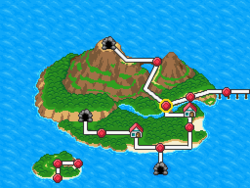
Location  Location of Latolato Trail in Oblivia. | |||||||||||||||
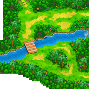
Latolato Trail (Japanese: ラトラトさんどう Latolato Mountain Path) is a location in Pokémon Ranger: Guardian Signs.
It is located north of Rand's House, south of Mt. Latolato and west of Hinder Cape on Renbow Island. A field of Gracideas can be seen after crossing the river using Suicune.
Nick's Bridge
The red-and-white striped bridge about halfway through the trail is a bridge built by Nick that had no name. During the quest "Ralph's Bright Idea", it is found out that Ralph and Nema both named the bridge the "Over the creek in the Green forest, the red-and-white-striped wonderfully crafted, Raikou Safe with no creaking renowned all over the world for connecting Yesterday and Tomorrow and Proudly-Built-by-Nick Bridge".
Pokémon
| Pokémon | Poké Assist | Field | |
|---|---|---|---|
| Venusaur * | |||
| Ledyba | |||
| Flaaffy | |||
| Bellossom * | |||
| Skiploom * | |||
| Mudkip | |||
| Bibarel * | |||
| Mothim * | |||
| Cherrim * | |||
| Stunky * | |||
| Gible * | |||
| Shaymin * | None | ||
In other languages
| ||||||||||||||||||
| This location-related article is a stub. You can help Bulbapedia by expanding it. |
| Oblivia | ||||||
|---|---|---|---|---|---|---|
|
| ||||||
| ||||||

|
This article is part of both Project Locations and Project Sidegames, Bulbapedia projects that, together, aim to write comprehensive articles on the Pokémon Locations and Sidegames, respectively. | 
|
