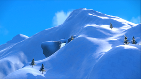
Glaseado Mountain

|
This article is incomplete. Please feel free to edit this article to add missing information and complete it. |
| ||||
| ||||
| Location: | North Province | |||
|---|---|---|---|---|
| Region: | Paldea | |||
| Generations: | IX | |||
| [[File:]] Location of Glaseado Mountain in Paldea. | ||||
| Pokémon world locations | ||||
Glaseado Mountain (Japanese: テンガン山 Mount Nappé) is the tallest mountain in the Paldea region, located in the region's North Province. The Glaseado Gym and the town of Montenevera are located here.
Geography
Glaseado Mountain is large and has a cold climate. It contains two of the Ten Sights of Paldea: Paldea's Highest Peak, the peak of Glaseado Mountain; and Glaseado's Grasp, a cliff named as such because it resembles a grasping hand.
Glaseado Mountain contains the town of Montenevera, as well as two Gyms: the Montenevera Gym and the Glaseado Gym. The Snow Slope Run, which is part of the Glaseado Gym Test, is done here.
Poké Mart
Items
Pokémon
Trainers
Trivia
Name origin
Glaseado Mountain is derived from glaseado (Spanish for icing).
Mount Nappé is derived from nappé (the culinary term for when a sauce is thick enough to coat the back of the spoon).
In other languages
| Language | Name | Origin |
|---|---|---|
| Japanese | ナッペ山 Mount Nappé | From nappé (the culinary term for when a sauce is thick enough to coat the back of the spoon) |
| English | Glaseado Mountain | From glaseado (Spanish for icing) |
| German | Montanata | From montaña (Spanish for mountain), montanha (Portuguese for mountain), and nata (Spanish and Portuguese for cream) |
| Spanish, Italian | Sierra Napada | From nappé and possibly Sierra Nevada |
| French | Mont Nappé | From nappé |
| Korean | 나페산 Nappé San | From nappé |
| Chinese (Mandarin) | 霜抹山 Shuāngmǒ Shān | From 霜 shuāng (frost) or 糖霜 tángshuāng (icing), 塗抹 túmǒ (to smear), and 山 shān (mountain) |
| Chinese (Cantonese) | 霜抹山 |
| Paldea | ||||||||||
|---|---|---|---|---|---|---|---|---|---|---|
|
| ||||||||||
| ||||||||||
|
|

|
This article is part of Project Locations, a Bulbapedia project that aims to write comprehensive articles on every location in the Pokémon world. |
