Potbottom Desert: Difference between revisions
From Bulbapedia, the community-driven Pokémon encyclopedia.
Jump to navigationJump to search
Celadonkey (talk | contribs) mNo edit summary |
|||
| Line 60: | Line 60: | ||
[[Category:Sword and Shield locations]] | [[Category:Sword and Shield locations]] | ||
[[Category:Isle of Armor]] | [[Category:Isle of Armor]] | ||
[[Category:Deserts]] | |||
[[de:Wüstensenke]] | [[de:Wüstensenke]] | ||
Revision as of 16:48, 26 June 2020

|
This article is incomplete. Please feel free to edit this article to add missing information and complete it. Reason: Geography, items, Pokémon |
| ||||
| ||||
| Location: | Isle of Armor | |||
|---|---|---|---|---|
| Region: | Galar | |||
| Generations: | VIII | |||
Location of Potbottom Desert in Galar. | ||||
| Pokémon world locations | ||||
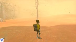
The Potbottom Desert (Japanese: 鍋底砂漠 Potbottom Desert) is a part of the Isle of Armor in the Galar region.
Geography
Items
Pokémon
Visible encounters
| Pokémon | Games | Location | Levels | Rate | |||||||||
|---|---|---|---|---|---|---|---|---|---|---|---|---|---|
| Sw | Sh |
Sand
|
10-15 | 32% | |||||||||
| Sw | Sh |
Sand
|
19-24 | 32% | |||||||||
| Sw | Sh |
Sand
|
10-15 | 2% | 2% | 2% | 2% | 2% | 2% | 2% | 2% | ||
| Sw | Sh |
Sand
|
19-24 | 2% | 2% | 2% | 2% | 2% | 2% | 2% | 2% | ||
| Sw | Sh |
Sand
|
10-15 | 2% | |||||||||
| Sw | Sh |
Sand
|
19-24 | 2% | |||||||||
| Sw | Sh |
Sand
|
10-15 | 5% | |||||||||
| Sw | Sh |
Sand
|
19-24 | 5% | |||||||||
| Sw | Sh |
Sand
|
10-15 | 20% | |||||||||
| Sw | Sh |
Sand
|
19-24 | 20% | |||||||||
| Sw | Sh |
Sand
|
10-15 | 56% | 36% | 36% | 56% | 56% | 56% | 36% | 36% | 56% | |
| Sw | Sh |
Sand
|
19-24 | 56% | 36% | 36% | 56% | 56% | 56% | 36% | 36% | 56% | |
| Sw | Sh |
Sand
|
19-24 | 10% | |||||||||
| Sw | Sh |
Sand
|
10-15 | 20% | |||||||||
| Sw | Sh |
Sand
|
19-24 | 10% | |||||||||
| Sw | Sh |
Sand
|
19-24 | 5% | |||||||||
| Sw | Sh |
Sand
|
10-15 | 5% | |||||||||
| Sw | Sh |
Sand
|
10-15 | 20% | |||||||||
| Sw | Sh |
Sand
|
19-24 | 20% | |||||||||
| Sw | Sh |
Sand
|
19-24 | 10% | |||||||||
| Sw | Sh |
Sand
|
10-15 | 20% | |||||||||
| Sw | Sh |
Sand
|
19-24 | 10% | |||||||||
| A colored background means that the Pokémon can be found in this location in the specified game. A white background with a colored letter means that the Pokémon cannot be found here. | |||||||||||||
In other languages
| ||||||||||||||||||||||||||

|
This article is part of Project Locations, a Bulbapedia project that aims to write comprehensive articles on every location in the Pokémon world. |


